Apr 05 2013
Shoebury Common Flood Defence
Thorpe Bay Yacht Club has long had the unencumbered use of the foreshore and our launching facilities. Rising global sea levels will, at some point well into the future, affect our facilities.
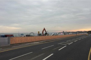
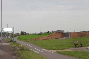
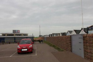
Southend Council have decided that the sea wall between the Coastguard Station and St Augustines Avenue needs to be raised now to prevent us being affected by the rising levels. The argument has long been raging as to whether this is needed now. Many believe that it is not – but the council believe that it is.
Link to Southend Councils Proposal Document
Link to details of Southend Councils Public Consultation
Southend Council have proposed a lifting of the sea wall and will give TBYC a sliding flood gate entrance to the water. The proposals will be up for Public consultation shortly with a meeting having been arranged for all members of the public to come and consult with representatives from Southend Council on Monday 22nd April at Shoebury High School Wendy Owen Hall, which is accessed through Caulfield Road (not the Sports hall as previously thought) at 7.30 pm (not 7 pm).
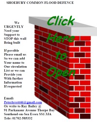
A Campaign group headed up by Peter Lovett has been discussing this and alternative schemes with the council and all interested parties. The alternative scheme is attached.
I believe that the Council’s proposed scheme will have a detrimental impact on our club and its use of the foreshore. I would, therefore, like you all to look at the attached alternative scheme, which would not impact as much with our Clubs use of the foreshore and will not cost Southend Council tax payers as much.
It would be good to see as many of you as possible at the Shoebury High School meeting on the 22nd April and support Thorpe Bay Yacht Club and the local community in making the right and informed choices for Southend-on-Sea.
Faithfully yours
Nick Elmore
Commodore
5 Responses to “Shoebury Common Flood Defence”
Leave a Reply
You must be logged in to post a comment.

Unfortunately the attached alternative scheme PDF seems to have lost its diagrams when seen with the latest Adobe Reader, the alternative option details thus being lost.
Bill, nothing has been added or removed during conversion, it is how it was delivered in word format from the author. We have emailed the author for more details for clarification of the alternative proposal.
Dear Nick,
Thank you for the email relating to the flood defense at Shoebury Common.
Whilst I appreciate all you do for the club I believe you are wrong on this occasion. I note with interest that neither yourself or Ray Bailey have a property that would be affected by any potential flooding and it is in the interest of the well being and safety of my family that I respond.
Putting this into perspective “On 1 February 1953, the North Sea Flood hit Canvey island during the night and caused the deaths of 58 people” I for one would not like to see a repeat of this headline.
Sadly like others I am unable to view any sketches in the alternative document and cannot make a fair and measured opinion of both schemes without these at present. However, in my opinion many of the arguments raised in the alleged alternative design scheme appear unsubstantiated, weak and simply flawed in some cases. The introduction sounds like a group of people sat around a table and raised a wish list and list of moans;
“Impact on disabled (Mobility impaired) gaining access..”, no substantiation provided.
“Loss of privacy..”, again not substantiated.
“Health & safety issues when crossing the road”?
“New secure beach huts..” how nice…why? (I have one and don’t believe the rest of Shoeburys rate payers should sponsor it).
“Lifting the promenade will strengthen the sea wall” will it?
“Raising the boat ramp 900mm to match MOD wall” If this relates to the TBYC slipway location? I cannot see this being practicable any ramp allowing vehicular access would have to start in the middle of the road. I could go on, and without disrespect the document appears to be the meanderings of an old man.
If there is to be a serious and viable alternative, it must be well thought out and properly presented, i would suggest the input of a designer/engineer to arrive at a proper scheme that will offer the needed protection. I work for one of the worlds largest Civil engineering companies, given the two offerings in there present form, the council’s option(s) appears the most valid.
Martyn
Being one who is interested to understand the background to posts and comments and the reality behind the headlines and also not wishing to be confused as answering for Nick I feel it necessary to express the following.
My first point is that this proposed scheme will present a very real disruption to club sailing access and if completed an ongoing unknown of when the proposed flood gate across the top of the slipway access will be closed thus no launching access at all. Nick was totally correct to bring this to us the members attention and in my opinion we should all sit up and take more notice before we wake up one morning and our playtime has changed forever.
Facts to inform on the 53 floods.
53 floods are a headline grabber, a very sad occasion where some of our more senior members helped those suffering in wakering and southchurch. Shoebury did not flood even though it did not have the current sea defences which are now built to withstand such an event. If 53 was ever to be repeated the southend coast is well protected, you can see that by just looking at the beach huts many of which are original from before the war and they did not float away in 1953.
I would not like to see any resident in any potential danger nor would I like to see any property developer or construction company benefiting from the proposed scheme which will destroy the beauty of shoebury common and our great seafront promenade forever.
NASA have done the most widely recognised and conclusive study of sea level change and it is widely supported at 3mm per year so in 100 years time this equates to only 300mm which in old money is just a foot! Leaving 4ft above the highest tides of sea wall defence we have at present.
Which guise of the largest construction company in the world stands to benefit from this 5million council scheme or others I am left asking…
We have the good fortune to have a beautiful scenic seafront, let us not be hoodwinked by the making of money to lose our town and clubs greatest asset.
On the other hand give the money and the cliff slip soil to Rochford council for some really needed protection from flooding from behind us via the river crouch and roach.
All the best
Peter
Hello all
As one of the team looking after the website I’ve uploaded a new version of the alternative scheme – a tidied version derived from documents received from the author via Paul Morgan.
The tidied version is now linked to the original post. My edits were made for readability (and on 18/4/2013 to update time & place in Post & leaflet, and link to Council’s Public Consultation page):
For comparison, here are links to original:
http://www.tbyc.org/wp-content/uploads/2013/04/Shoebury-Common-Leaflet.pdf and edited:
http://www.tbyc.org/wp-content/uploads/2013/04/Shoebury_Common_Leaflet-tidied.pdf
cheers
Bill Dashfield
PS Speaking personally, as a club member and non-Thorpe Bay resident, both schemes increase the height of walls between the road and the sea, having the effect of reducing access and views from the cycle track, road and grassed picnic areas between houses and the sea.
As the areas south of Thorpe Bay Gardens road and Shoebury Common Road are basically used for recreation, protecting them and these roads from occasional (ten yearly? twenty yearly? fifty yearly?) short term flooding seems to me less of a priority that preserving their recreational value, if this can be done without putting houses at risk.
I wonder why the following (my words and suggestions based on Council’s Option 2) was not fully presented as an option:
Looking at the Councils’s list of benefits for their proposed option:
– Existing level of flood protection maintained throughout construction;
– Avoids the immediate need for raising and replacing the existing seawall;
– On completion the existing sea views from the promenade will be maintained.
– Minimised disruption to the beach, promenade and beach huts within frontage;
– Material from a local cliff stabilisation project utilised within the landscaping of the
defence.
– Improved flood protection for both the café and car park;
– Limited disruption to the beach, beach huts, promenade and car park; and
– Continued (although restricted) access to the promenade, beach, café and car
park will be maintained throughout construction.
– On completion continued access to the promenade, beach and slipway from
Ness Road will be maintained.
This option provides all of these except:
– Minimised disruption to Thorpe Esplanade and Shoebury Common Road;
– Improved flood protection for both the café and car park;
The disruption to Shoebury Common Road would be limited to raising it with ramp/berm; and occasional short closures due to flooding
Adding flooding proofing to the cafe and road services (e.g. flood proof door & window shutters on cafe, moving electrical connections up) may be feasible. It is arguable that the cafe would suffer less from this and occasional flooding that from the sea being less accessible and visible.
The Council’s FAQ has a partial answer:
2. Why is the Council raising the defences in an area where the nearest houses are built on high ground?
Accepting the need to prevent “a route for water to flow into the low-lying area”, the disadvantages presented are:
Surely the costs of building (possibly higher) earth berms to link up must be considerably less than the much longer similar berms suggested along the seaward side of the common?
That leave the additional costs of the (worst case) flood barrier across the road of 12 total height
As to visual impact – would a short stretch of earth berm across a grassed area, plus 6′ high shutter posts at the roadway be worse than a 6′ foot wall/berm blocking off the sea along the whole stretch?
Artists impressions from Council’s proposal:
More (and clearer) information from the Council on costs and implications of this option would be helpful.
Whatever scheme goes forward must also allow for river flooding, consideration of which seems to be omitted, but from residents’ comments seen is as severe a risk.
cheers
Bill
PPS For example: Smaller flood defenses at Walton-on-the-Naze. The berm is (I think) about 10′; the flood gate about 4-5′ high
View Larger Map
View Larger Map